 Live Radio
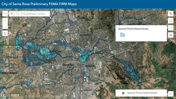 photo credit: courtesy of City of Santa Rosa
A screenshot of the FEMA Preliminary Flood Map for the City of Santa Rosa
Santa Rosa has published a new FEMA Preliminary Flood Map with updated information on local flood zones. Claire Myers, Storm Water & Creeks Manager for the City of Santa Rosa, says the map focuses on the Santa Rosa Creek watershed, including what FEMA calls Special Flood Hazard Areas.
"High risk means there's a 1% chance of flooding annually. Properties in these areas may be subject to flood insurance requirements and stricter building standards," said Myers.
Myers says this means if your property is in a Special Flood Hazard Area and you have a federally backed mortgage, flood insurance will likely be required by your lender. Even without a federally backed mortgage, flood insurance is highly recommended.
"If it looks like your property does touch the special flood hazard area, I would say call your insurance agent and they will be able to help walk you through whether or not insurance is required for you," Myers said.
The maps also have big implications for building projects. Stricter building standards apply to properties in floodplains, even if the house itself isn't directly impacted.
"Say the flood waters just come into your backyard and don't touch your house but you're considering building a new garage or putting in an ADU in your backyard, there may be different and more strict building standards for your parcel," said Myers.
The City of Santa Rosa worked closely with FEMA, and while the maps largely align with the city's own flood models, some discrepancies were addressed according to Myers.
"The City along with Sonoma Water and the County of Sonoma did weigh in on the data that FEMA used," Myers said. "There were certain sections of the map that didn't align with our flood study and we were able to get those excluded."
The downtown Santa Rosa area is significantly impacted due to existing infrastructure limitations. Myers says mitigation efforts are underway, and the maps will help guide future projects and grant applications.
“The city will be sending mailers to all properties that are touched by the special flood hazard area as well as renters and the mailers will have more information about where to look for information and we'll also have information about the community meeting with FEMA and the National Flood Insurance Program," said Myers.
That meeting will be held online on Wednesday, September 10th at 6pm. For property owners, the next step will be a 90-day appeal and comment period which will happen sometime this winter.
To view the preliminary maps, visit srcity.org/femafloodmapping.
